Зміни лісопокритої площі та незаконні рубки в Українських Карпатах в перехідний період з 1988 по 2007 рр.
Про цю статтю я дізнався від Голови Львівської обласної громадської екологічної організації «Західноукраїнське об’єднання лісівників і екологів» Андрія Сенюка під час відрядження на Львівщину у рамках програми FLEG. Автори використали космічні карти та новітні компові технології для оцінки обезлісення.
Ресурс, на якому розміщена стаття, платний, а ще треба мати й відповідні технічні можливості для оплати. Може хтось має українську версію публікації тощо – поділіться. Дуже вже хочеться дізнатися, наскільки полисіли Карпати. Тут викладаю посилання, резюме та усе інше, що можна отримати безкоштовно.
Олег Листопад
Forest cover change and illegal logging in the Ukrainian Carpathians in the transition
period from 1988 to 2007
Pages 1194-1207
Tobias Kuemmerle, Oleh Chaskovskyy, Jan Knorn, Volker C. Radeloff, Ivan Kruhlov, William S. Keeton, Patrick Hostert
Abstract
Illegal logging is a major environmental and economic problem, and exceeds in some countries the amounts of legally harvested timber. In Eastern Europe and the former Soviet Union, illegal logging increased and reforestation on abandoned farmland was widespread after the breakdown of socialism, and the region’s forest cover trends remain overall largely unclear. Our goal here was to map forest cover change and to assess the extent of illegal logging and reforestation in the Ukrainian Carpathians. We used Landsat TM/ETM+ images and Support Vector Machines (SVM) to derive forest change trajectories between 1988 and 2007 for the entire Ukrainian Carpathians. We calculated logging and reforestation rates, and compared Landsat-based forest trends to official statistics and inventory maps. Our classification resulted in reliable forest/non-forest maps (overall accuracies between 97.1%–98.01%) and high clear cut detection rates (on average 89.4%).
Forest cover change was widespread in the Ukrainian Carpathians between 1988 and 2007. We found forest cover increase in peripheral areas, forest loss in the interior Carpathians, and increased logging in remote areas. Overall, our results suggest that unsustainable forest use from socialist times likely persisted in the post-socialist period, resulting in a continued loss of older forests and forest fragmentation. Landsat-based forest trends differed substantially from official forest resource statistics. Illegal logging appears to have been at least as extensive as documented logging during the early 1990s and so-called sanitary clear-cuts represent a major loophole for overharvesting and logging in restricted areas. Reforestation and illegal logging are frequently not accounted for in forest resource statistics, highlighting limitations of these data. Combating illegal logging and transitioning towards sustainable forestry requires better monitoring and up-to-date accounting of forest resources, in the Carpathians and elsewhere in Eastern Europe, and remote sensing can be a key technology to achieve these goals.
Keywords: Forest harvesting; Illegal logging; Forest disturbance; Landsat; Support vector machines; Ukraine; Carpathians; Forest inventory data; Forest resource assessment; Post-socialist transition
Article Outline
- 1. Introduction
- 2. Study region
- 3. Datasets used and methodology
- 3.1. Satellite images and ancillary data
- 3.2. Forest cover change mapping using support vector machines
- 3.3. Analyzing forest cover change
- 4. Results
- 5. Discussion
- 5.1. Post-socialist forest cover trends and illegal logging in the Ukrainian Carpathians
- 5.2. Change detection approach
- 6. Conclusions
- Acknowledgements
- References
Figures
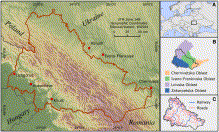 Study region in the Ukrainian Carpathians. Main frame: study region boundaries (red), topography (elevation range > 100–2,060 m), and major population centers. Inset A: location of the study region in Europe. Inset B: the four provinces (oblasts) comprising the Ukrainian Carpathians. Inset C: Major roads and railway tracks. Source: SRTM DEM (elevation data); ESRI World Data and Maps Kit 2005 (national boundaries and population centers); Geodezkartinformatyka (1997) (oblast boundaries, roads, railways).
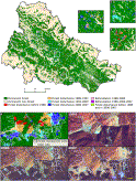 Fig. 2. Top: Forest cover changes between 1988 and 2007. Bottom: Comparison of the satellite-based forest cover change map, stand-level forest management maps, and Landsat TM/ETM+ images from 1994, 2000, 2007 for an area close to Rakhiv, Zakarpatska Oblast. Source: Ukrainian National Forestry University (inventory maps).
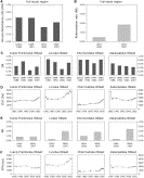 Fig. 3. Remote-sensing-based disturbance and reforestation rates at the study region and oblast level and forest resource statistics at the oblast level from the Statistical Yearbook of Ukraine (2006 and 2007). A: Annual disturbance rates for the full study region. B: Reforestation in the study region (relative to 1988-non-forest land). C: Annual disturbance rates (DR) per oblast. D: Official trends in forest regeneration (i.e., clear-cut) area (CCA) per oblast. E: Reforestation rates (RR, relative to 1988-non-forest land) per oblast. F: Official trends in forest planting area (FPA) per oblast. Source: (The State Statistics Committee of Ukraine, 2006) and (The State Statistics Committee of Ukraine, 2007) (forest resource statistics).
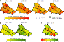 Fig. 4. Disturbance rates (DR), reforestation rates (RR), and relative net change (RNC) rates at the raion level. A: Annual disturbance rates. B: Reforestation in the study region (relative to 1988-non-forest land). C: Net forest cover change (relative to raion area). Source: Geodezkartinformatyka (1997) (oblast and raion boundaries).
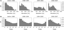 Fig. 5. Changes in disturbance rates by elevation (A) and slope (B).
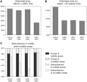 Fig. 6. Disturbed area above and below 1,100 m elevation (A), and on slopes > 20° and < 20° (B). Proportions of forest and disturbances in areas visible or invisible from major roads and railway tracks (C).
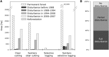 Fig. 7. A: Distribution of permanent forest, disturbances, and reforestation mapped from the Landsat images for four forest management practices documented in the inventory map (clear cutting, sanitary clear-cutting, selective logging, and sanitary selective logging) (A). Visual assessment of 100 forest management polygons designated as clear-cuts in the inventory data.
All polygons were checked against the Landsat images, whether forest cover was intact, partially removed, or fully removed (B).
29.06.2010 | комментария 2 »
Теги: Карпати
1.Июль.2010 о 11:15
[…] Вдалося отримати повний текст статті "Forest cover change and illegal logging in the Ukrainian Carpathians in the transition period from 1988 to 2007", про яку ми згадували в одному з попередніх повідомлень! […]
17.Июль.2010 о 10:46
[…] методом космічної зйомки. Один із співавторів статті "Зміни лісопокритої площі та незаконні рубки в Українс… Олег Часковський є доцентом кафедри лісової таксації […]